Hatchery → Puntledge Park
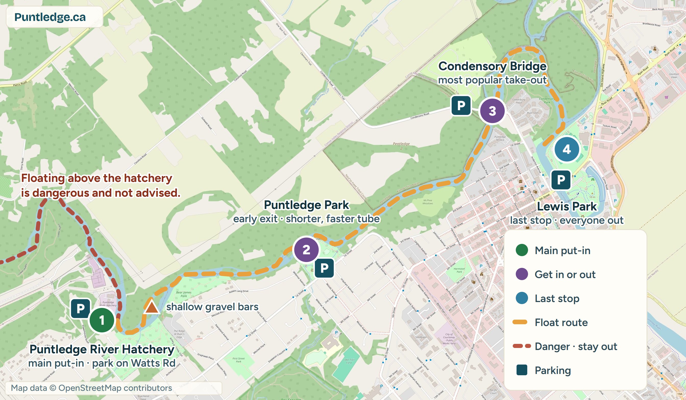
Put in at the Puntledge River Hatchery, the most common starting spot, and hop out early at Puntledge Park. The quicker, livelier tube for when you’re short on time.
The Puntledge runs from Comox Lake down into Courtenay. Tubers stick to the lower, mellow half. Everything upstream of the marked put-ins belongs to the dam, the falls, and the expert kayakers.
Cell signal is spotty on the river. Keep a copy on your phone.
For orientation, not navigation. Markers are approximate, so scout your put-in and take-out from shore before you launch. Map data © OpenStreetMap contributors.
Sirens along the river mean water is rising: get out of the channel immediately. BC Hydro releases water from the Comox Dam without public notice. Never float upstream of the diversion dam or anywhere near Nymph Falls, Barber's Hole, or the powerhouse.
All three floats put in at the Puntledge River Hatchery. Park along Watts Rd near the trailhead. Get directions to the put-in
Put in at the Puntledge River Hatchery, the most common starting spot, and hop out early at Puntledge Park. The quicker, livelier tube for when you’re short on time.
The full classic run. Most floaters get out at Condensory Bridge, especially when the tide is rolling in, since everything below it turns into a slow, lazy grind.
Float all the way into Courtenay. Lewis Park is the LAST exit before the estuary. The final leg is tidal. An incoming tide means real paddling, so check tide times first.
Look at today’s report, the dam-release note, and the weather before anyone gets in a car.
Leave a car, a bike, or a patient friend at your exit: Puntledge Park, Condensory Bridge, or Lewis Park. Floating past it means a long, soggy walk back.
At the hatchery, park along Watts Rd near the trailhead. Wherever you stop, obey the posted signs: don’t block driveways, farm gates, or emergency routes, and launch from the gravel bars, not private banks. Some lots are gated and lock at set times (Lewis Park included), and we don’t track those hours. Tickets, tows, and break-ins all happen, so take your valuables with you.
Know what your take-out looks like before you launch: scout it from shore when you drop the shuttle. Miss it and your last chance is Lewis Park. After that it’s tidal estuary, and an incoming tide will fight you the whole way.
Take 30 seconds to report your float: water level, crowds, anything weird. That’s what keeps this site useful.
Whatever floats in with you, floats out with you. There are bins at Puntledge Park and Lewis Park.
Check today's conditions before you drive out. The river changes day to day.
See today's report